


20200916 lac Escarcets 3

Sugg
User
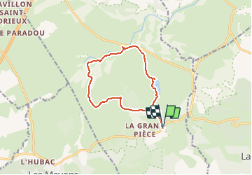

Length
13.2 km

Max alt
126 m

Uphill gradient
107 m
Km-Effort
14.6 km

Min alt
68 m

Downhill gradient
107 m
Boucle
Yes
Creation date :
2020-09-16 07:13:50.851
Updated on :
2020-09-16 13:12:14.8
5h57
Difficulty : Easy

FREE GPS app for hiking
 SityTrail
IGN / Geographical institutes
SityTrail Plus
The world is yours!
About
Trail Walking of 13.2 km to be discovered at Provence-Alpes-Côte d'Azur, Var, Le Cannet-des-Maures. This trail is proposed by Sugg.
Description
rando de reprise
Positioning
Country:
France
Region :
Provence-Alpes-Côte d'Azur
Department/Province :
Var
Municipality :
Le Cannet-des-Maures
Location:
Unknown
Start:(Dec)
Start:(UTM)
290308 ; 4800695 (32T) N.
Comments